
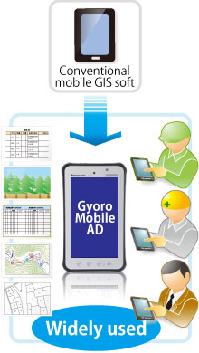
GyoroMobileAD
This product is navigation and tracking tool that can be used on a smartphone easily and usefully also you can still enjoy same level of superior operability as GyoroMobile.
October 10, 2013 We have started to offer GyoroMbile AD "trial" set.
October 10, 2013 GyoroMobile AD prices have been revised.
January 10, 2013 GyoroMobile AD's video manual has been released.
Concept
GyoroMobileAD is a new form of the GyoroMobile for PDA, you can still enjoy same level of superior operability and also GyoroMobileAD was developed to be able to use even on a smartphone.
New functions have been added to take full advantage of the many functions unique to smartphones.
It is not only the conventional tracking function or navigation function it can be widely used in the following fields as an information browsing device that can be used in the field.
| Forest management | Boundary management woods section, browsing survey book in the local. |
| Farmland management | Boundary management of parcel, browsing farmland ledger in the local. |
| Environmental survey | Collect and record local information in geological surveys and dose surveys. |
| Survey support | Record of survey data, survey support. |
| Cadastral management | Ledger browsing for each lot number. |
| Construction Architecture | Progress management in the field, browsing drawings. |
| Equipment management | Browse Equipment information, Customer Ledger |
| Disaster prevention support | Grasp hazardous areas, management of evacuation routes and evacuation facilities. |
For mobile GIS software on the market,
- Many functions and difficult to operate.
- The display layout is complicated and the characters are too small to see.
- Only the map is possible to use that already built into the product.
We might get these complaints.
GyoroMobileAD is designed with the following concept to meet these requests.
Simple and clear operating system
It is an intuitive and simple operation system that you can use with confidence even if you are not accustomed to handle digital devices.Also, the display layout is as simple as possible and the text is displayed in a large size that can be used for elderly people.

Simple Functional Configuration
We try to minimize the functional configuration and reduce the effort required to learn about software.
GyoroMobileAD is designed to understand almost all functions if you operate for about 30 minutes.

General purpose hardware configuration
If introduce all-in-one hardware terminal with built-in GPS and dedicated software from the beginning, the operation is easy, however can be assumed in following the problems.
- Hardware price is high because it is a dedicated machine.
- If break a part of equipment, you might have to pay an expensive repair fee or purchase it all again.
- When upgrading the version of the equipment, you have to purchase it all again.
GyoroMobile is available for a smartphone loaded with android.Also, you can connect to the GPS terminal via Bluetooth. We believe that configurations will provide the following advantages.
- If it is a general purpose smart phone or a GPS terminal, you can purchase each comparatively cheaply.
- Even if a smartphone or GPS terminal broke, you just have to purchase only the part of broken equipment.
- As the performance of smartphones and GPS terminals improve year by year, it is possible to switch to the latest equipment reasonably by partly purchasing.

Main function
GyoroMobileAD has the following functions.
Map reading function
It can read vector data of a shapefile format and image data in and use it as a map.You can also use your own map data and image files as a background map.Map data file is placed on the smartphone's built-in storage therefore it is possible to use outdoors without any network communication problems.

GPS connection function
It can connect with GPS that built-in a smartphone.
It can also use Bluetooth connection function of the smartphone to connect to an external GPS terminal.

Navigation function
It can confirm the distance and direction to the destination on the smartphone.

Tracking function
Connect GPS and record easily what you locus and moved.
Locus can be saved as point data of a shapefile format therefore you can use commercial GIS software.

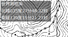
Multi-coordinate system display
Different coordinate systems of map data can be displayed overlap.
It supports JGD2000, Tokyo Datum, Plane rectangular coordinate system, WGS84.
Measurement function
It can measure the distance between two points and the area of a polygon.

Editing function
You can add comments on the map.
You can construct lines and polygons.
You can easily construct and edit memo, lines, and polygons.

New added function
GyoroMobileAD has the following function that GyoroMobile does not have.
Performance improvement
It became able to display large image files and map data at high speed.
Also, the map data of the J-StimsV2 format used in the National Forest GIS etc. can be converted and displayed.

Information browsing function(GyoroLinks)
You can download and browsing the necessary document files from the server.
Also, you can upload tracking data, survey data, image, video, audio that is obtained at the local to the server.

The tracking data that is uploaded to the server can be downloaded from the server by using GyoroView on the computer at the office.
Multimedia function
You can launch a camera that is built-in your smartphone and mapping the captured image directly onto the maps.
Not only camera images also video and audio can be mapping on the map as well.
3D function
It is possible to check the local situation in 3D display three dimensionally what has been check planar up to now.
You can three dimensionally grasp the locus of GPS tracking and the distance to the destination.

AR function
3D data can be overlaid and displayed in real time in the camera image.
By holding the camera, you can check the names of nearby places that mountains and rivers, and grasp the target points and boundaries on the camera image.
For example, if you register a landslide area with 3D data, the disaster area will be reflected in the camera image.
Equip with map data (optional)
he map to equip can be chosen according to the application.
Please consult us at the time of introduction.
Security function(optional)
When you lose the device, you can delete the data of the device or stop the function by remote operation from the server.
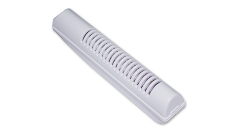
Dose measurement function(optional)
By connecting an external Geiger counter (GyoroGeiger), the measured air dose can be mapping on the map as it is.
Operating environment
Android 3.2 or later
Japanese is displayed for Japanese OS, English is displayed for non-Japanese OS or English version OS.
supported model
The operation of the following models has been confirmed.
Please contact us if you have a model that you would like to support.


Price
Usage charge
The usage charge for GyoroMobileAD is in the table below.
By paying the annual usage charges, you can use GyoroLinks and GyoroViewWhiteBase as well as GyoroMobileAD.
| Eligible Products | Initial registration fee | First year | 2nd year | 3rd year and later |
|---|---|---|---|---|
| GyoroMobileAD GyoroLinks GyoroViewWhiteBase |
¥10,000 | ¥45,600/year (¥3,800/month) |
¥33,600/year (¥2,800/month) |
¥21,600/year (¥1,800/month) |
- The above prices are not included tax. Tax will be included when charge.
- It will be yearly payment.
- It will contract one year at least.
- After cancel the contract, we will charge initial registration fee if you register again.
- The prices we are posting will be a direct sales price that case if you purchase directly from us.
Please note that the price may change depending on the sales channel when you go through an agency or a trading company or when it becomes a bid case.
Pay up-front price
We also offer a system that allows you to pay up front for the customers who have difficulty in continuing payment.
The prepaid price is in below.
| Course | Eligible Products | price | remark |
|---|---|---|---|
| 2 years | GyoroMobileAD GyoroLinks GyoroViewWhiteBase |
¥169,200 |
|
| 3 years | ¥190,800 |
| |
| 5 years | ¥234,000 |
|
- The above prices are not included tax. It will be included when charge.
- Other than the listed prices, we also offer direct sales prices. Please contact us if you are interested.
- Please contact us for the complete purchase price of the software.
Roadmap
GyoromobileAD services will be provided sequentially according to the roadmap below.
roadmappackage
We introduce the package product of GyoroMobileAD.
Decontamination work support package.
This package was developed for the purpose of efficiently and safely conducts decontamination work and dose surveys by utilizing tablet devices and smartphones.
The two configurations powerfully support radiation dose measurement and decontamination work.


Future application fields
We believe that GyoroMobileAD can be used in the following fields.
Please contact us if you are interested.


