GyoroView
We aimed to develop this software to be “easy and simple for everyone”.
It’s an intuitive and easy to use even if you are not accustomed to use PC.
Concept
We aimed to develop GyoroView to be “easy and simple for everyone”.
In general, GIS soft on the market is each comparatively expensive. If you consider using it with multiple people, such as a team or group, you will spend a lot of money just for license of the software.
However, when you actually introduce it, in most cases, the only thing that is really needed for management is a part of functions for GIS software.Also, the function has been developed in a general purpose for the masses, therefore what you would like to do is simple, and however the operation procedure might be troublesome.
In that case, rather than using a multi-functional and expensive GIS software, it is better to customize a simple however low-cost GIS software and use something optimized for business, and we think that is an excellent use in terms of cost and efficiency at the time of introduce.
GyoroView has been developed as a base system to provide such "GIS that is perfect much for your business".Advanced overlay function and spatial search function are built-in however it does not appear in the menu.たThe idea is to provide the necessary and minimum functions by customization.
Simple and clear operating system
It is an intuitive and simple operation system that you can use with confidence even if you are not accustomed to handle digital devices and PC.
For example, to open a map file, just drop the map file from Explorer, in the print function, the map screen becomes the preview screen as it is.
Simple Functional Configuration
We try to minimize the functional configuration and reduce the effort required to learn about software. When using multi-functional software for the first time, have you ever been overwhelmed by the so many menus and icons on the screen, or tired of the thick operating manual?
GyoroView is designed to understand almost all functions if you operate for about 30 minutes. Because, the customer's important purpose is to look at and analyze the information you have, not the thing to be familiar with GIS or software.
Light performance
The application starts quickly, therefore you can start it up without stress when you would like to use it. GyoroView is designed to allow you to browse a wide area of maps even on the PC that the CPU power is poor. Therefore, even if you read a large amount of map data (for example, a Shape file of several tens of MB or several GB image files) you can zoom in, zoom out, and scroll smoothly.
To begin with "see"
To see the map data as a picture on the screen, differences of data formats, coordinate systems, system of units, etc. various conditions must be cleared. It developed from the viewpoint that "first of all, making it easy to overlay and see the various map data on hand".
Main function
GyoroView has the following functions.
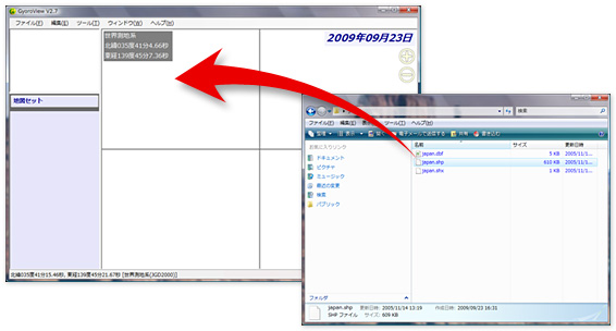
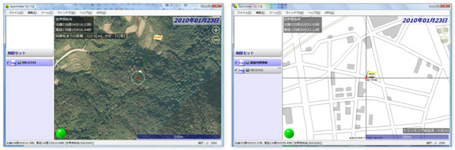
Direct display of file
If you drop the map data of Shapefile format, GeoTiff format, and J-STIMS V2 format on the screen can be displayed on the screen by data conversion and coordinate transformation. In addition to the above, bmp, jpg, png format images, Geospatial information Authority of japan 1/25,000 numerical map image, Geospatial information Authority of japan 1/25,000 numerical map colored image open and display. You can scan your drawings and maps for easy use.
Multi-coordinate system display
Different coordinate systems of map data can be displayed overlap.
It supports JGD2000, Tokyo Datum, Plane rectangular coordinate system, WGS84.
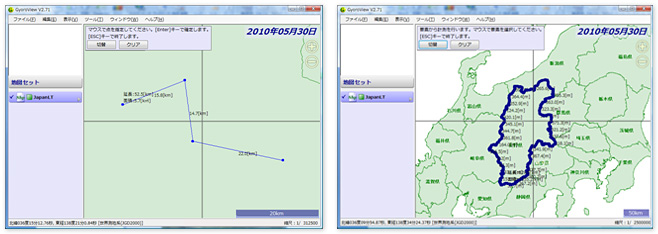
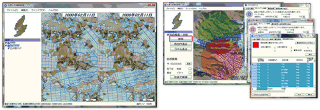
Measurement function
It can measure the distance between two points and the area of a polygon.
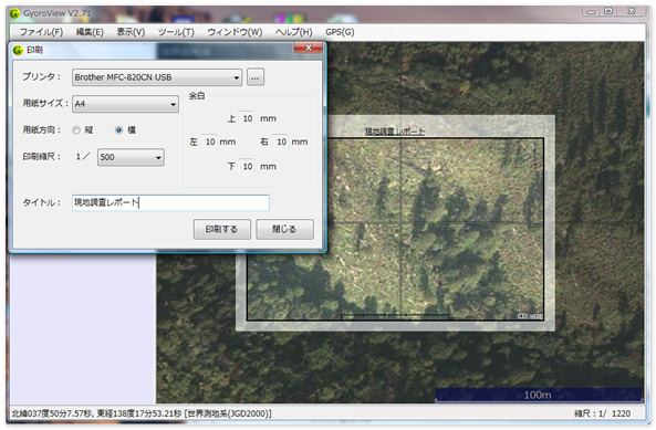
Printing function (Paid optional)
It has a print function that makes it easy to specify the range you would like to print on the map.
Editing function (Paid optional)
You can create a new map data (Shapefile format) to construct points, lines, and polygons.
GPS function(Paid optional)
It can connect to GPS for tracking, navigation and surveying easily.
You can also display the track log (MNEA format, waypoint) obtained by GPS.
Operating environment
Microsoft WindowsXP、WindowsVista、Windows7
If you have Microsoft WindowsXP you need Microsoft .net framework V2.0 or later
If it is Japanese OS it will be displayed Japanese, if it is English or other than Japanese OS it will be displayed English.
Related services
Related to GyoroView introduction, we also support the service in the below.
Consulting during installation
We will help to consider how to get the most effective and reasonable result out of it, when customer introduce GIS system or improving an existing system.
Please feel free to contact us.
Map data maintenance service
This service allows to digitalization their drawings and maps that customers have and make them available on GyoroView.
Please contact us because the cost depends on the state and quantity of the drawing.
Customization service
This is a service that additional develops search and analysis functions on a map that specializes in your business.
The cost depends on the content of the function that developing. Please contact us.
Introduction record
Introducing examples of system introduction using GyoroView.
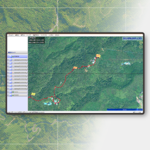
Sado Toki Protection Project Paddy Field Information Management Prototype System
The satellite image of the entire Sado area and the paddy field polygons are displayed in a superimposed manner, and paddy fields can be searched using geographical and attribute conditions.Used for research and analysis of paddy field environment suitable for habitat of ibis. It mainly has the following functions.
- Display function of satellite image and paddy field polygon
- Paddy field search function by geographical conditions (range search)
- Paddy field search function by attribute condition (attribute search)
- Overlay function of paddy field extracted by geographic condition and attribute condition
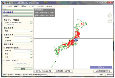
Rare animal and plant database system
This system creates a database of national red data books and displays the habitat distribution and ecosystem of rare flora and fauna on a map. It mainly has the following functions.
- Display function of national forests and quasi-national parks nationwide
- Rare flora and fauna search function
- Display function of rare animal and plant habitat
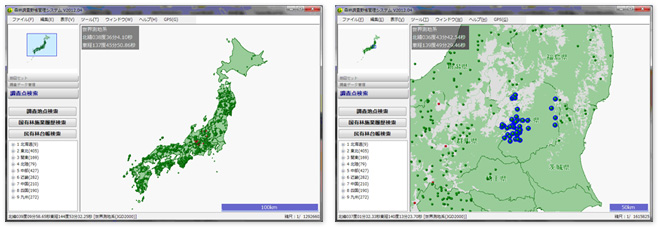
Survey point information management system
This system creates a database of forest survey information nationwide and displays the distribution of survey points and survey information on a map. It mainly has the following functions.
- Investigation point display function
- Survey point search function
- Investigation information display function
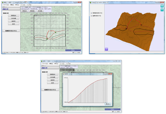
Road network route search tool
As a part of road planning for the entire forest planning area, it is a tool to assist in route search especially for low-profile logging road networks. Creating a tractor road on a topographic map generates an optimal tractor route route from the topographical conditions. It mainly has the following functions.
- Route route generation function
- 3D display function
- Vertical view display function
Price
GyoroView is provided free of charge to both corporation and personal.
Please download it from here and use it.
The price for paid optional is in the table below.
However, only customers who have purchased GyoroMobile will be offered a paid option for free.
| Customer | Content | Price (Tax excluded) |
|---|---|---|
| Corporation・Public institution | We will respond to inquiries by email or phone. The support period is one year from the date of purchase. |
¥30000 |
| Personal | ¥10000 | |
| Educational | ¥5000 |
*The above is the price of one license (used on one pc).
Purchase Procedures
Please visit inquiry page and contact us and ask that "you would like to purchase GyoroView."
In that time, please fill the following items.
- Name of the corporation or institutions and address.
- Name
- Contact information (phone number e-mail address)
We will send you an e-mail with cost estimate.
After you have deposited the payment, we will send you a license code for the software by email (We will mail the cost estimate and the invoice).
Please download the software from the Download page.
Trial download service
Service content
We offer a trial version of the software.
The functions of trial version are the same as in the production version.
As a general rule, the trial period is one month.
How to apply
Please visit inquiry page and contact us and ask that "you would like to have GyoroView trial service."
In that time, please fill the following items.
- Name of the corporation or institutions and address.
- Name
- Contact information (phone number e-mail address)
We will issue a license code for the trial.
Please download the software from the Download page.
Customization service
Service content
We can customize the GyoroView according to your business purpose.
We will estimate the cost according to the content to be customized.
How to apply
Please visit inquiry page and contact us and ask that "you would like to have GyoroView customization service.
In that time, please fill the following items.
- Name of the corporation or institutions and address
- Name
- Contact information (phone number e-mail address)
We will contact you about specific details.