GyoroMobile
This product is navigation and tracking tool which can be used on a mobile device loaded with Windows Mobile easily and usefully.
Announcement
Thank you for visiting page of GyoroMobile.
We have continued to offer mobile GIS "GyoroMobile" that can be used with PDA devices.
However, with the spread of smartphones in the last few years, it has become difficult to obtain low price, high-performance PDA terminals.
In order to respond to these market trends, we have prepared and recommended the mobile GIS "GyoroMobile AD" which can be used on smartphones for customers who are considering a new introduction.
GyoroMobileAD is a new form of the GyoroMobile for PDA. you can still enjoy the same level of superior operability, however the function and performance improved significantly.
Please also take a look page of GyoroMobileAD.
Concept
GyoroMobile is software that became possible to navigation and tracking, measure spot for forest surveys and climbing by using commercial mobile device (PDA or mobile phone) and GPS device.
It can use easily for everybody.
For mobile GIS software on the market,
- Many functions and difficult to operate.
- The display layout is complicated and the characters are too small to see.
- Only the map is possible to use that already built into the product.
We might get these complaints.
GyoroMobile is designed with the following concept to meet these requests.
Simple and clear operating system
It is an intuitive and simple operation system that you can use with confidence even if you are not accustomed to handle digital devices.
Also, the display layout is as simple as possible and the text is displayed in a large size which can be used for elderly people.
Simple Functional Configuration
We try to minimize the functional configuration and reduce the effort required to learn about software.
GyoroMobile is designed to understand almost all functions if you operate for about 30 minutes.
General purpose hardware configuration
If introduce all-in-one hardware terminal with built-in GPS and dedicated software from the beginning, the operation is easy, however can be assumed the problems which are in below.
- Hardware price is high because it is a dedicated machine.
- If break a part of equipment, you might have to pay an expensive repair fee or purchase it all again.
- When upgrading the version of the equipment, you have to purchase it all again.
GyoroMobile is available for a mobile phone or PDA loaded with Windows Mobile.
Also, you can connect to the GPS terminal via Bluetooth.
We believe that configurations will provide the following advantages.
- If it is a general purpose PDA terminal or a GPS terminal, you can purchase each comparatively cheaply.
- Even if a smartphone or GPS terminal broke, you just have to purchase only the part of broken equipment.
- As the performance of PDA terminal and GPS terminals improve year by year, it is possible to switch to the latest equipment reasonably by partly purchasing.
Main function
GyoroMobile has the following functions.
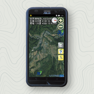
Map reading function
It can read vector data of a shapefile format and image data in and use it as a map.
You can also use your own map data and image files as a background map.
Map data file is placed on the SD card of mobile device therefore it is possible to use outdoors without any network communication problems.
GPS connection function
It can connect with GPS which built-in a mobile device.
It can also use Bluetooth connection function of the mobile device to connect to an external GPS terminal.
Navigation function
It can confirm the distance and direction to the destination on the smartphone.
Tracking function
Connect GPS and record easily what you locus and moved.
Locus can be saved as point data of a shapefile format therefore you can use commercial GIS software.
Record point
You can use the checkpoint function to record especially where you would like to record, when you are on the move.
It is possible to surveying easily by using this function.
Multi-coordinate system display
Different coordinate systems of map data can be displayed overlap.
It supports JGD2000, Tokyo Datum, Plane rectangular coordinate system, WGS84.
Measurement function
It can measure the distance between two points and the area of a polygon.
Editing function
You can add comments on the map.
You can construct lines and polygons.
You can easily construct and edit memo, lines, and polygons.
Screen lock function
If you actually use it outdoors, it might touch the screen and cause an unexpected operation while you're moving and your mobile device is in your pocket.
With the screen lock function, you can prevent such careless operation.
Surrounding survey support function (Paid optional)
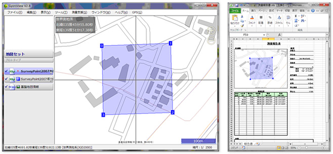
From GyoroMobile V2.8, "Surrounding survey support function" has been added to support surveying work more powerfully at the local.The purpose of the Surrounding survey support function is to be able to immediately check the survey results obtained in the field as a picture.
In addition, the output function of the survey report makes the work of the report which had been time-consuming up to now more comfortable.
The surrounding survey support function loaded the following new function.
Survey results input function
It can input azimuth and elevation angle sloped distance on PDA device easily.
It saves you the trouble of making notes on paper and digitizing them again in the office.
Real time form display
The survey results you input are displayed immediately as polygons on the map.
Therefore, you can always see the survey results on the map.
Area, extension, and closing errors (ratio of closure) are also displayed in real time.
If you specify a magnetic declination you can also support to the gap of the orientation.
Closing processing
You can also do closing processing of survey result (Correction of errors between the beginning and end) imminently.
Output of survey results
The survey results will be saved in SHAPE format, so you can reproduce them on a map just by reading them into GIS software after you return to the office.
Output survey report
In GyoroViewV2.8, you can create an Excel report by simply dropping the survey results (SHAPE file) and selecting the output function of the survey report.
Report of Excel can adjust the layout freely to suit your operations.
Operating environment
Microsoft Windows Mobile 5.0/6.0/6.5
If you have Microsoft Windows Mobile 5.0 you need Microsoft .net compact framework V2.0 or later.
If it is Japanese OS it will be displayed Japanese, if it is English or other than Japanese OS it will be displayed English.
Related services
Related to GyoroMobile introduction, we also support the service in the below.
Introduction consulting
We will help to consider how to get the most effective and reasonable result out of it, when customer introduce GyoroMobile.
Please feel free to contact us.
Map data maintenance service
This service allows to digitalization their drawings and maps that customers have and make them available on GyoroMobile.
Please contact us, the cost depends on the state and quantity of the drawing.
Customization service
This is a service that additional develops search and analysis functions on a map that specializes in your business.
Please contact us, the cost depends on the content of the function that developing.
Introduction record
GyoroMobile has partnered with a forest survey company to conduct actual forest surveys over the past four years.
As a result of the introduction, we have been evaluated that it was effective enough.
For example,
- You can use the images and maps that you usually use in the local as it is.
- It is able to reach places you have never visited before without lost.
- It is sure to come back from the mountain.
Introducing the introduction record of GyoroMobile.
Introduction record for public institution
Forestry Agency CHUBU Regional Forest Office KANTO Regional Forest Office SHIKOKU Regional Forest Office
Osaka Prefectural Government Nagasaki Prefectural Government Kagoshima Prefecture Government
It is used for local work in national forests and privately owned forest.
Usage performance for oversea
Brazil, Philippines, Vietnam, Burkina Faso, Malaysia, Cambodia
Price
The price for GyoroMobile is in the table below.
| Customer | Content | Price (Tax excluded) |
|---|---|---|
| Corporation・Public institution | We will respond to inquiries by email or phone. The support period is one year from the date of purchase. |
¥70,000 |
| Personal | ¥50,000 | |
| Educational Institutions | ¥30,000 |
*The above is the price of one license (used on one pc).
- If you would like to initial setup the software, we will charge one set ¥3000 + shipping fee.
- We will estimate the conduct of operation briefings in local according to the scale and number of times.
- If you would like to support after the second year also, the support fee is as shown in the following table.
| Customer | Content | Price (Tax excluded) |
|---|---|---|
| Corporation・Public institution | We will respond to inquiries by email or phone. The support period is one year from the date of purchase. |
¥30,000 |
| Personal | ¥10,000 | |
| Educational Institutions | ¥5,000 |
| Customer | Content | Price (Tax excluded) |
|---|---|---|
| Corporation・Public institution | We will respond to inquiries by email or phone. The support period is one year from the date of purchase. |
¥7,000 |
| Personal | ¥5,000 | |
| Educational Institutions | ¥3,000 |
Purchase Procedures
Please visit inquiry page and contact us and ask that "you would like to purchase GyoroMobile."
In that time, please fill the following items.
- Name of the corporation or institutions and address.
- Name
- Contact information (phone number e-mail address)
After you have deposited the payment, we will send you a license code for the software by email (We will mail the cost estimate and the invoice).
Please download the software from the Download page.
Trial download service
Service content
We offer a trial version of the software.
The functions of trial version are the same as in the production version.
As a general rule, the trial period is one month.
How to apply
Please visit inquiry page and contact us and ask that "you would like to have GyoroMobile trial service."
In that time, please fill the following items.
- Name of the corporation or institutions and address.
- Name
- Contact information (phone number e-mail address)
We will issue a license code for the trial.
Please download the software from the Download page.
Rental service
Eligible service
This service is eligible only for Corporation, Public institution, Educational institution.
Service content
We will lend a complete set of mobile devices with the software installed for free.
As a general rule, the trial period is one month.
How to apply
Please visit inquiry page and contact us and ask that "you would like to have GyoroMobile rental service."
In that time, please fill the following items.
- Name of the corporation or institutions and address.
- Name
- Contact information (phone number e-mail address)
We will contact you about specific details.
Customization service
Service content
We customize the GyroMobile to suit your business application.
We will estimate the cost according to the content to be customized.
How to apply
Please visit inquiry page and contact us and ask that "you would like to have GyoroMobile customization service."
In that time, please fill the following items.
- Name of the corporation or institutions and address.
- Name
- Contact information (phone number e-mail address)
We will contact you about specific details.